Geoscience of the future: from coordinate systems to gravity analysis
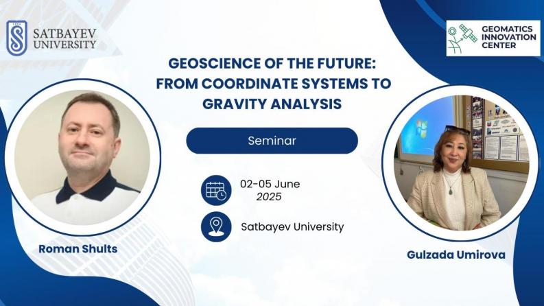
Join us at Satbayev University this June 2–5, 2025 for the international seminar "Geoscience of the Future: From Coordinate Systems to Gravity Analysis", organized by the Geomatics Innovation Center, Satbayev University.
This seminar will bring together leading experts and applied professionals to discuss modern methods of coordinate transformation, GNSS data integration, and their practical application in geospatial monitoring and natural resource assessment.
Speakers:
Dr. Roman Shults –– expert in geodetic modeling and GNSS data integration – will cover:
▪ Coordinate systems in local monitoring projects and transformation methods
▪ Least-squares collocation techniques for spatial data integration
▪ Modeling of high-precision reference surfaces for geospatial monitoring
▪ Integration and reduction of terrestrial and GNSS-based geodetic networks
▪ Accuracy assessment of aligning GNSS and terrestrial data with global geoid models
▪ Use of polynomial and spline surfaces for reference modeling
▪ Investigation into the reliability of such alignments in practical applications
Dr. Gulzada Umirova, a leading gravimetry scientist, will present:
▪ Application of High-Precision Gravimetric Exploration in Solving Subsoil Use Problems
The seminar will be relevant for:
▪ Professionals in geodesy, GIS, cartography, and gravimetry
▪ Researchers, lecturers, and postgraduate students in technical and geoscientific fields
▪ Engineers and spatial data specialists working on monitoring systems
What to expect:
– In-depth theoretical and applied sessions
– Practical insights and current case studies
– Exchange between academia, industry, and national research initiatives
Venue: Satbayev University, Almaty
Dates: June 2–5, 2025
Register here: https://forms.gle/5ZYMRvfCAVbaSM2p6
The event is part of the national research project BR21882366:"Development of the geoid model of the Republic of Kazakhstan as the basis of a unified national coordinate and height system", implemented within the Geomatics Innovation Center.